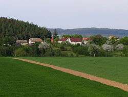
Krahulov
| Krahulov | |||
|---|---|---|---|
| Municipality | |||
 | |||
| |||
 Krahulov | |||
| Coordinates: 49°13′20″N 15°48′20″E / 49.22222°N 15.80556°ECoordinates: 49°13′20″N 15°48′20″E / 49.22222°N 15.80556°E | |||
| Country |
| ||
| Region | Vysočina | ||
| District | Třebíč | ||
| Area | |||
| • Total | 4.89 km2 (1.89 sq mi) | ||
| Elevation | 467 m (1,532 ft) | ||
| Population (2009) | |||
| • Total | 231 | ||
| • Density | 47/km2 (120/sq mi) | ||
| Postal code | 675 21 | ||
| Website | http://www.krahulov.cz | ||


Krahulov is a village and municipality (obec) in Třebíč District in the Vysočina Region of the Czech Republic.
The municipality covers an area of 4.89 square kilometres (1.89 sq mi), and has a population of 231 (as at 29 May 2009).
Krahulov lies approximately 6 kilometres (4 mi) west of Třebíč, 25 km (16 mi) south-east of Jihlava, and 139 km (86 mi) south-east of Prague.
References
| Wikimedia Commons has media related to Krahulov. |
This article is issued from Wikipedia - version of the 4/7/2016. The text is available under the Creative Commons Attribution/Share Alike but additional terms may apply for the media files.