Montenescourt
| Montenescourt | |
|---|---|
 | |
 Montenescourt | |
|
Location within Hauts-de-France region  Montenescourt | |
| Coordinates: 50°17′36″N 2°37′31″E / 50.2933°N 2.6253°E / 50.2933; 2.6253Coordinates: 50°17′36″N 2°37′31″E / 50.2933°N 2.6253°E / 50.2933; 2.6253 | |
| Country | France |
| Region | Hauts-de-France |
| Department | Pas-de-Calais |
| Arrondissement | Arras |
| Canton | Beaumetz-lès-Loges |
| Intercommunality | Val de Gy |
| Government | |
| • Mayor (2008–2014) | Bernard Libessart |
| Area1 | 5.08 km2 (1.96 sq mi) |
| Population (2006)2 | 431 |
| • Density | 85/km2 (220/sq mi) |
| Time zone | CET (UTC+1) |
| • Summer (DST) | CEST (UTC+2) |
| INSEE/Postal code | 62586 / 62123 |
| Elevation |
76–127 m (249–417 ft) (avg. 83 m or 272 ft) |
|
1 French Land Register data, which excludes lakes, ponds, glaciers > 1 km² (0.386 sq mi or 247 acres) and river estuaries. 2 Population without double counting: residents of multiple communes (e.g., students and military personnel) only counted once. | |
Montenescourt is a commune in the Pas-de-Calais department in the Hauts-de-France region of France.
Geography
Montenescourt is situated 7 miles (11 km) west of Arras, at the junction of the D61 and the D56 roads.
Population
| 1962 | 1968 | 1975 | 1982 | 1990 | 1999 | 2006 |
|---|---|---|---|---|---|---|
| 137 | 153 | 227 | 362 | 418 | 408 | 431 |
| Census count starting from 1962: Population without duplicates | ||||||
Places of interest
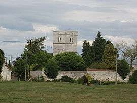
- The church of St.Leger, dating from the seventeenth century.
See also
References
External links
| Wikimedia Commons has media related to Montenescourt. |
- Montenescourt on the Quid website (French)
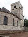 The church
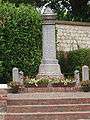 The war memorial
| Authority control |
|---|
This article is issued from Wikipedia - version of the 11/6/2016. The text is available under the Creative Commons Attribution/Share Alike but additional terms may apply for the media files.