Saint-Paulet-de-Caisson
| Saint-Paulet-de-Caisson | ||
|---|---|---|
|
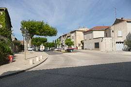
A view of Saint-Paulet-de-Caisson | ||
| ||
 Saint-Paulet-de-Caisson | ||
|
Location within Occitanie region  Saint-Paulet-de-Caisson | ||
| Coordinates: 44°15′51″N 4°35′53″E / 44.2642°N 4.5981°ECoordinates: 44°15′51″N 4°35′53″E / 44.2642°N 4.5981°E | ||
| Country | France | |
| Region | Occitanie | |
| Department | Gard | |
| Arrondissement | Nîmes | |
| Canton | Pont-Saint-Esprit | |
| Intercommunality | ValCezArd | |
| Government | ||
| • Mayor (2008–2014) | Christophe Serre | |
| Area1 | 16.88 km2 (6.52 sq mi) | |
| Population (2008)2 | 1,781 | |
| • Density | 110/km2 (270/sq mi) | |
| Time zone | CET (UTC+1) | |
| • Summer (DST) | CEST (UTC+2) | |
| INSEE/Postal code | 30290 / 30130 | |
| Elevation |
50–293 m (164–961 ft) (avg. 100 m or 330 ft) | |
|
1 French Land Register data, which excludes lakes, ponds, glaciers > 1 km² (0.386 sq mi or 247 acres) and river estuaries. 2 Population without double counting: residents of multiple communes (e.g., students and military personnel) only counted once. | ||
.svg.png)
Saint-Paulet-de-Caisson is a commune in the Gard department in southern France.
Population
| Historical population | ||
|---|---|---|
| Year | Pop. | ±% |
| 1962 | 870 | — |
| 1968 | 930 | +6.9% |
| 1975 | 944 | +1.5% |
| 1982 | 1,141 | +20.9% |
| 1990 | 1,431 | +25.4% |
| 1999 | 1,602 | +11.9% |
| 2008 | 1,781 | +11.2% |
See also
References
| Wikimedia Commons has media related to Saint-Paulet-de-Caisson. |
This article is issued from Wikipedia - version of the 11/9/2016. The text is available under the Creative Commons Attribution/Share Alike but additional terms may apply for the media files.