Souspierre
| Souspierre | |
|---|---|
 | |
 Souspierre | |
|
Location within Auvergne-Rhône-Alpes region  Souspierre | |
| Coordinates: 44°32′31″N 4°57′36″E / 44.542°N 4.960°ECoordinates: 44°32′31″N 4°57′36″E / 44.542°N 4.960°E | |
| Country | France |
| Region | Auvergne-Rhône-Alpes |
| Department | Drôme |
| Arrondissement | Nyons |
| Canton | Dieulefit |
| Intercommunality | Pays de Dieulefit |
| Government | |
| • Mayor (2008–2014) | Alain Piet Berton de Lestrade |
| Area1 | 5.25 km2 (2.03 sq mi) |
| Population (2008)2 | 104 |
| • Density | 20/km2 (51/sq mi) |
| Time zone | CET (UTC+1) |
| • Summer (DST) | CEST (UTC+2) |
| INSEE/Postal code | 26343 / 26160 |
| Elevation |
228–635 m (748–2,083 ft) (avg. 250 m or 820 ft) |
|
1 French Land Register data, which excludes lakes, ponds, glaciers > 1 km² (0.386 sq mi or 247 acres) and river estuaries. 2 Population without double counting: residents of multiple communes (e.g., students and military personnel) only counted once. | |
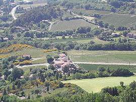
Souspierre is a commune in the Drôme department in southeastern France.
Population
| Historical population | ||
|---|---|---|
| Year | Pop. | ±% |
| 1911 | 160 | — |
| 1962 | 63 | −60.6% |
| 1968 | 71 | +12.7% |
| 1975 | 72 | +1.4% |
| 1982 | 84 | +16.7% |
| 1990 | 99 | +17.9% |
| 1999 | 96 | −3.0% |
| 2008 | 104 | +8.3% |
See also
References
| Wikimedia Commons has media related to Souspierre. |
This article is issued from Wikipedia - version of the 10/28/2016. The text is available under the Creative Commons Attribution/Share Alike but additional terms may apply for the media files.