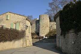
Vaunaveys-la-Rochette
| Vaunaveys-la-Rochette | |
|---|---|
 | |
 Vaunaveys-la-Rochette | |
|
Location within Auvergne-Rhône-Alpes region  Vaunaveys-la-Rochette | |
| Coordinates: 44°46′N 5°02′E / 44.76°N 5.03°ECoordinates: 44°46′N 5°02′E / 44.76°N 5.03°E | |
| Country | France |
| Region | Auvergne-Rhône-Alpes |
| Department | Drôme |
| Arrondissement | Die |
| Canton | Crest-Nord |
| Intercommunality | Val de Drôme |
| Government | |
| • Mayor (2008–2014) | Éric Chareyre |
| Area1 | 21.93 km2 (8.47 sq mi) |
| Population (2008)2 | 573 |
| • Density | 26/km2 (68/sq mi) |
| Time zone | CET (UTC+1) |
| • Summer (DST) | CEST (UTC+2) |
| INSEE/Postal code | 26365 / 26400 |
| Elevation |
193–808 m (633–2,651 ft) (avg. 300 m or 980 ft) |
|
1 French Land Register data, which excludes lakes, ponds, glaciers > 1 km² (0.386 sq mi or 247 acres) and river estuaries. 2 Population without double counting: residents of multiple communes (e.g., students and military personnel) only counted once. | |
Vaunaveys-la-Rochette is a commune in the Drôme department in southeastern France.
Population
| Historical population | ||
|---|---|---|
| Year | Pop. | ±% |
| 1911 | 440 | — |
| 1962 | 392 | −10.9% |
| 1968 | 392 | +0.0% |
| 1975 | 350 | −10.7% |
| 1982 | 401 | +14.6% |
| 1990 | 448 | +11.7% |
| 1999 | 548 | +22.3% |
| 2008 | 573 | +4.6% |
See also
References
| Wikimedia Commons has media related to Vaunaveys-la-Rochette. |
This article is issued from Wikipedia - version of the 10/28/2016. The text is available under the Creative Commons Attribution/Share Alike but additional terms may apply for the media files.