Wattwiller
| Wattwiller Wǎttwillr | ||
|---|---|---|
| ||
 Wattwiller | ||
|
Location within Grand Est region 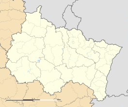 Wattwiller | ||
| Coordinates: 47°50′13″N 7°10′51″E / 47.8369°N 7.1808°ECoordinates: 47°50′13″N 7°10′51″E / 47.8369°N 7.1808°E | ||
| Country | France | |
| Region | Grand Est | |
| Department | Haut-Rhin | |
| Arrondissement | Thann-Guebwiller | |
| Canton | Cernay | |
| Intercommunality | Cernay et environs | |
| Government | ||
| • Mayor (2008–2014) | Jacques Muller (Green) | |
| Area1 | 13.61 km2 (5.25 sq mi) | |
| Population (2006)2 | 1,762 | |
| • Density | 130/km2 (340/sq mi) | |
| Time zone | CET (UTC+1) | |
| • Summer (DST) | CEST (UTC+2) | |
| INSEE/Postal code | 68359 / 68700 | |
| Elevation |
266–1,121 m (873–3,678 ft) (avg. 360 m or 1,180 ft) | |
|
1 French Land Register data, which excludes lakes, ponds, glaciers > 1 km² (0.386 sq mi or 247 acres) and river estuaries. 2 Population without double counting: residents of multiple communes (e.g., students and military personnel) only counted once. | ||
.svg.png)
Wattwiller (Alemannic German: Wǎttwillr; German: Wattweiler) is a communes in the Haut-Rhin department in Grand Est in north-eastern France.
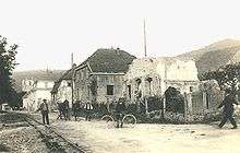
Wattwiller ruins in 1920
Located near Hartmannswillerkopf, it was a strategic village during World War Two.
Nowadays Wattwiller is known for its mineral water.
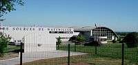 Factory
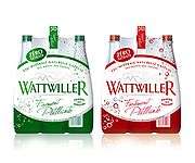 Wattwiller mineral water
See also
References
| Wikimedia Commons has media related to Wattwiller. |
This article is issued from Wikipedia - version of the 11/13/2016. The text is available under the Creative Commons Attribution/Share Alike but additional terms may apply for the media files.