Ardengost
| Ardengost | ||
|---|---|---|
|
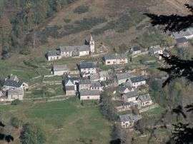
An overhead view of the village | ||
| ||
 Ardengost | ||
|
Location within Occitanie region  Ardengost | ||
| Coordinates: 42°55′33″N 0°24′18″E / 42.9258°N 0.405°ECoordinates: 42°55′33″N 0°24′18″E / 42.9258°N 0.405°E | ||
| Country | France | |
| Region | Occitanie | |
| Department | Hautes-Pyrénées | |
| Arrondissement | Bagnères-de-Bigorre | |
| Canton | Arreau | |
| Intercommunality | Aure | |
| Government | ||
| • Mayor (2008–2014) | Christian Oeuillet | |
| Area1 | 5.82 km2 (2.25 sq mi) | |
| Population (2009)2 | 17 | |
| • Density | 2.9/km2 (7.6/sq mi) | |
| Time zone | CET (UTC+1) | |
| • Summer (DST) | CEST (UTC+2) | |
| INSEE/Postal code | 65023 / 65240 | |
| Elevation |
715–1,927 m (2,346–6,322 ft) (avg. 1,060 m or 3,480 ft) | |
|
1 French Land Register data, which excludes lakes, ponds, glaciers > 1 km² (0.386 sq mi or 247 acres) and river estuaries. 2 Population without double counting: residents of multiple communes (e.g., students and military personnel) only counted once. | ||
.svg.png)
Ardengost is a commune in the Hautes-Pyrénées department in southwestern France.
Population
| Historical population | ||
|---|---|---|
| Year | Pop. | ±% |
| 1962 | 16 | — |
| 1968 | 23 | +43.8% |
| 1975 | 19 | −17.4% |
| 1982 | 19 | +0.0% |
| 1990 | 11 | −42.1% |
| 1999 | 16 | +45.5% |
| 2007 | 16 | +0.0% |
| 2009 | 17 | +6.2% |
See also
References
| Wikimedia Commons has media related to Ardengost. |
This article is issued from Wikipedia - version of the 2/11/2016. The text is available under the Creative Commons Attribution/Share Alike but additional terms may apply for the media files.