Gratentour
| Gratentour | ||
|---|---|---|
 | ||
| ||
 Gratentour | ||
|
Location within Occitanie region  Gratentour | ||
| Coordinates: 43°43′19″N 1°25′56″E / 43.7219°N 1.4322°ECoordinates: 43°43′19″N 1°25′56″E / 43.7219°N 1.4322°E | ||
| Country | France | |
| Region | Occitanie | |
| Department | Haute-Garonne | |
| Arrondissement | Toulouse | |
| Canton | Fronton | |
| Intercommunality | Hers Garonne | |
| Government | ||
| • Mayor (2008–2014) | Paul Franchini | |
| Area1 | 4.09 km2 (1.58 sq mi) | |
| Population (2008)2 | 3,626 | |
| • Density | 890/km2 (2,300/sq mi) | |
| Time zone | CET (UTC+1) | |
| • Summer (DST) | CEST (UTC+2) | |
| INSEE/Postal code | 31230 / 31150 | |
| Elevation |
123–194 m (404–636 ft) (avg. 170 m or 560 ft) | |
|
1 French Land Register data, which excludes lakes, ponds, glaciers > 1 km² (0.386 sq mi or 247 acres) and river estuaries. 2 Population without double counting: residents of multiple communes (e.g., students and military personnel) only counted once. | ||
.svg.png)
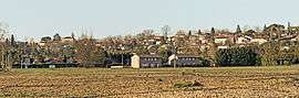
Gratentour is a commune in the Haute-Garonne department in southwestern France.
Population
| Historical population | ||
|---|---|---|
| Year | Pop. | ±% |
| 1962 | 388 | — |
| 1968 | 646 | +66.5% |
| 1975 | 924 | +43.0% |
| 1982 | 1,574 | +70.3% |
| 1990 | 2,518 | +60.0% |
| 1999 | 3,035 | +20.5% |
| 2008 | 3,626 | +19.5% |
Monument
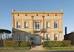 Town hall
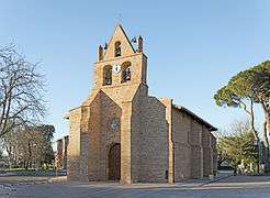 Sainte Quitterie church
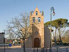 Bell gabel of Sainte Quitterie church
See also
References
| Wikimedia Commons has media related to Gratentour. |
This article is issued from Wikipedia - version of the 11/18/2014. The text is available under the Creative Commons Attribution/Share Alike but additional terms may apply for the media files.