Proupiary
| Proupiary | |
|---|---|
|
Abbey of Bonnefont | |
 Proupiary | |
|
Location within Occitanie region  Proupiary | |
| Coordinates: 43°09′39″N 0°51′45″E / 43.1608°N 0.8625°ECoordinates: 43°09′39″N 0°51′45″E / 43.1608°N 0.8625°E | |
| Country | France |
| Region | Occitanie |
| Department | Haute-Garonne |
| Arrondissement | Saint-Gaudens |
| Canton | Saint-Martory |
| Intercommunality | Canton de Saint-Martory |
| Government | |
| • Mayor (2008–2014) | Chantal Rivière |
| Area1 | 4.95 km2 (1.91 sq mi) |
| Population (2008)2 | 67 |
| • Density | 14/km2 (35/sq mi) |
| Time zone | CET (UTC+1) |
| • Summer (DST) | CEST (UTC+2) |
| INSEE/Postal code | 31440 / 31360 |
| Elevation |
340–483 m (1,115–1,585 ft) (avg. 425 m or 1,394 ft) |
|
1 French Land Register data, which excludes lakes, ponds, glaciers > 1 km² (0.386 sq mi or 247 acres) and river estuaries. 2 Population without double counting: residents of multiple communes (e.g., students and military personnel) only counted once. | |
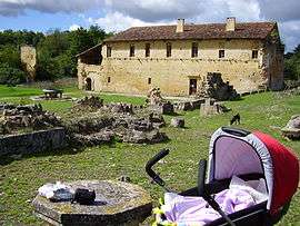
Proupiary is a commune in the Haute-Garonne department in southwestern France. The remains of the Bonnefont Abbey are situated in the commune.[1]
Population
| Historical population | ||
|---|---|---|
| Year | Pop. | ±% |
| 1962 | 47 | — |
| 1968 | 51 | +8.5% |
| 1975 | 50 | −2.0% |
| 1982 | 71 | +42.0% |
| 1990 | 53 | −25.4% |
| 1999 | 56 | +5.7% |
| 2008 | 67 | +19.6% |
See also
References
- ↑ Mérimée PA00135703, Ministère français de la Culture. (fr)
| Wikimedia Commons has media related to Proupiary. |
This article is issued from Wikipedia - version of the 11/6/2016. The text is available under the Creative Commons Attribution/Share Alike but additional terms may apply for the media files.