Kučerov
| Kučerov | |||
|---|---|---|---|
| Municipality | |||
 | |||
| |||
 Kučerov | |||
| Coordinates: 49°13′9″N 17°0′23″E / 49.21917°N 17.00639°ECoordinates: 49°13′9″N 17°0′23″E / 49.21917°N 17.00639°E | |||
| Country |
| ||
| Region | South Moravian | ||
| District | Vyškov | ||
| Area | |||
| • Total | 8.75 km2 (3.38 sq mi) | ||
| Elevation | 291 m (955 ft) | ||
| Population (2006) | |||
| • Total | 465 | ||
| • Density | 53/km2 (140/sq mi) | ||
| Postal code | 683 31 | ||
| Website | http://www.kucerov.cz/ | ||


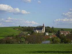
Kučerov is a village and municipality (obec) in Vyškov District in the South Moravian Region of the Czech Republic.
The municipality covers an area of 8.75 square kilometres (3.38 sq mi), and has a population of 465 (as at 3 July 2006).
Kučerov lies approximately 6 kilometres (4 mi) south of Vyškov, 29 km (18 mi) east of Brno, and 210 km (130 mi) south-east of Prague.
References
| Wikimedia Commons has media related to Kučerov. |
This article is issued from Wikipedia - version of the 9/12/2016. The text is available under the Creative Commons Attribution/Share Alike but additional terms may apply for the media files.