Vertheuil
| Vertheuil | ||
|---|---|---|
|
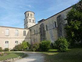
St. Pierre abbey | ||
| ||
 Vertheuil | ||
|
Location within Nouvelle-Aquitaine region  Vertheuil | ||
| Coordinates: 45°15′04″N 0°49′59″W / 45.2511°N 0.8331°WCoordinates: 45°15′04″N 0°49′59″W / 45.2511°N 0.8331°W | ||
| Country | France | |
| Region | Nouvelle-Aquitaine | |
| Department | Gironde | |
| Arrondissement | Lesparre-Médoc | |
| Canton | Pauillac | |
| Intercommunality | Centre Médoc | |
| Government | ||
| • Mayor (2008–2014) | Rémi Jarris | |
| Area1 | 21.94 km2 (8.47 sq mi) | |
| Population (2008)2 | 1,181 | |
| • Density | 54/km2 (140/sq mi) | |
| Time zone | CET (UTC+1) | |
| • Summer (DST) | CEST (UTC+2) | |
| INSEE/Postal code | 33545 / 33180 | |
| Elevation |
5–35 m (16–115 ft) (avg. 12 m or 39 ft) | |
|
1 French Land Register data, which excludes lakes, ponds, glaciers > 1 km² (0.386 sq mi or 247 acres) and river estuaries. 2 Population without double counting: residents of multiple communes (e.g., students and military personnel) only counted once. | ||
.svg.png)
Vertheuil is a commune in the Gironde department in Nouvelle-Aquitaine in southwestern France.
Population
| Historical population | ||
|---|---|---|
| Year | Pop. | ±% |
| 1962 | 724 | — |
| 1968 | 765 | +5.7% |
| 1975 | 753 | −1.6% |
| 1982 | 910 | +20.8% |
| 1990 | 1,075 | +18.1% |
| 1999 | 1,068 | −0.7% |
| 2008 | 1,181 | +10.6% |
See also
References
| Wikimedia Commons has media related to Vertheuil. |
This article is issued from Wikipedia - version of the 11/9/2016. The text is available under the Creative Commons Attribution/Share Alike but additional terms may apply for the media files.