Villeveyrac
| Villeveyrac | ||
|---|---|---|
|
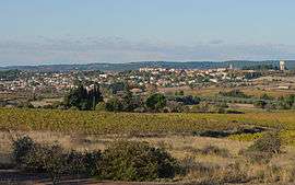
A general view of Villeveyrac | ||
| ||
 Villeveyrac | ||
|
Location within Occitanie region  Villeveyrac | ||
| Coordinates: 43°30′07″N 3°36′29″E / 43.5019°N 3.6081°ECoordinates: 43°30′07″N 3°36′29″E / 43.5019°N 3.6081°E | ||
| Country | France | |
| Region | Occitanie | |
| Department | Hérault | |
| Arrondissement | Montpellier | |
| Canton | Mèze | |
| Intercommunality | Bassin de Thau | |
| Government | ||
| • Mayor (2008–2014) | Alain Jeantet | |
| Area1 | 37.12 km2 (14.33 sq mi) | |
| Population (2008)2 | 2,905 | |
| • Density | 78/km2 (200/sq mi) | |
| Time zone | CET (UTC+1) | |
| • Summer (DST) | CEST (UTC+2) | |
| INSEE/Postal code | 34341 / 34560 | |
| Elevation |
12–255 m (39–837 ft) (avg. 75 m or 246 ft) | |
|
1 French Land Register data, which excludes lakes, ponds, glaciers > 1 km² (0.386 sq mi or 247 acres) and river estuaries. 2 Population without double counting: residents of multiple communes (e.g., students and military personnel) only counted once. | ||

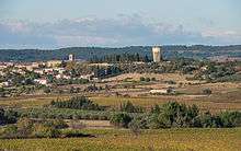
The church and the water tower.
Villeveyrac is a commune in the Hérault department in the Occitanie region in southern France.
Population
| Historical population | ||
|---|---|---|
| Year | Pop. | ±% |
| 1962 | 1,571 | — |
| 1968 | 1,609 | +2.4% |
| 1975 | 1,618 | +0.6% |
| 1982 | 1,686 | +4.2% |
| 1990 | 1,842 | +9.3% |
| 1999 | 2,211 | +20.0% |
| 2008 | 2,905 | +31.4% |
See also
References
| Wikimedia Commons has media related to Villeveyrac. |
This article is issued from Wikipedia - version of the 11/12/2016. The text is available under the Creative Commons Attribution/Share Alike but additional terms may apply for the media files.