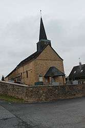
Vrigne-Meuse
| Vrigne-Meuse | ||
|---|---|---|
 | ||
| ||
 Vrigne-Meuse | ||
|
Location within Grand Est region 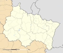 Vrigne-Meuse | ||
| Coordinates: 49°42′12″N 4°50′48″E / 49.7033°N 4.8467°ECoordinates: 49°42′12″N 4°50′48″E / 49.7033°N 4.8467°E | ||
| Country | France | |
| Region | Grand Est | |
| Department | Ardennes | |
| Arrondissement | Charleville-Mézières | |
| Canton | Flize | |
| Intercommunality | Pays des Sources au Val de Bar | |
| Government | ||
| • Mayor (2008–2014) | Jean-Christophe Chanot | |
| Area1 | 4.44 km2 (1.71 sq mi) | |
| Population (2008)2 | 232 | |
| • Density | 52/km2 (140/sq mi) | |
| Time zone | CET (UTC+1) | |
| • Summer (DST) | CEST (UTC+2) | |
| INSEE/Postal code | 08492 / 08350 | |
| Elevation |
146–243 m (479–797 ft) (avg. 151 m or 495 ft) | |
|
1 French Land Register data, which excludes lakes, ponds, glaciers > 1 km² (0.386 sq mi or 247 acres) and river estuaries. 2 Population without double counting: residents of multiple communes (e.g., students and military personnel) only counted once. | ||

Vrigne-Meuse is a commune in the Ardennes department in northern France.
Population
| Historical population | ||
|---|---|---|
| Year | Pop. | ±% |
| 1962 | 176 | — |
| 1968 | 178 | +1.1% |
| 1975 | 183 | +2.8% |
| 1982 | 207 | +13.1% |
| 1990 | 187 | −9.7% |
| 1999 | 191 | +2.1% |
| 2008 | 232 | +21.5% |
See also
References
| Wikimedia Commons has media related to Vrigne-Meuse. |
This article is issued from Wikipedia - version of the 9/10/2016. The text is available under the Creative Commons Attribution/Share Alike but additional terms may apply for the media files.