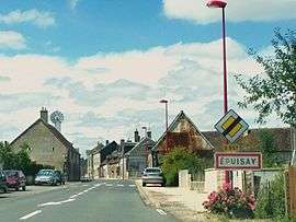
Épuisay
| Épuisay | ||
|---|---|---|
 | ||
| ||
 Épuisay | ||
|
Location within Centre-Val de Loire region 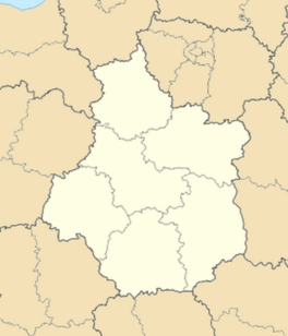 Épuisay | ||
| Coordinates: 47°54′04″N 0°55′56″E / 47.9011°N 0.9322°ECoordinates: 47°54′04″N 0°55′56″E / 47.9011°N 0.9322°E | ||
| Country | France | |
| Region | Centre-Val de Loire | |
| Department | Loir-et-Cher | |
| Arrondissement | Vendôme | |
| Canton | Savigny-sur-Braye | |
| Intercommunality | Coteaux de la Braye | |
| Government | ||
| • Mayor (2014–2020) | Michel Deniau | |
| Area1 | 23.52 km2 (9.08 sq mi) | |
| Population (2013)2 | 787 | |
| • Density | 33/km2 (87/sq mi) | |
| Time zone | CET (UTC+1) | |
| • Summer (DST) | CEST (UTC+2) | |
| INSEE/Postal code | 41078 / 41360 | |
| Elevation |
119–182 m (390–597 ft) (avg. 164 m or 538 ft) | |
|
1 French Land Register data, which excludes lakes, ponds, glaciers > 1 km² (0.386 sq mi or 247 acres) and river estuaries. 2 Population without double counting: residents of multiple communes (e.g., students and military personnel) only counted once. | ||
.svg.png)
Épuisay is a commune in the Loir-et-Cher department of central France.
Population
| Historical population | ||
|---|---|---|
| Year | Pop. | ±% |
| 1793 | 761 | — |
| 1806 | 804 | +5.7% |
| 1821 | 875 | +8.8% |
| 1831 | 992 | +13.4% |
| 1841 | 935 | −5.7% |
| 1851 | 981 | +4.9% |
| 1861 | 1,024 | +4.4% |
| 1872 | 901 | −12.0% |
| 1881 | 887 | −1.6% |
| 1891 | 897 | +1.1% |
| 1901 | 857 | −4.5% |
| 1911 | 892 | +4.1% |
| 1921 | 768 | −13.9% |
| 1931 | 739 | −3.8% |
| 1946 | 680 | −8.0% |
| 1954 | 667 | −1.9% |
| 1962 | 590 | −11.5% |
| 1968 | 541 | −8.3% |
| 1975 | 492 | −9.1% |
| 1982 | 526 | +6.9% |
| 1990 | 539 | +2.5% |
| 1999 | 532 | −1.3% |
| 2008 | 700 | +31.6% |
| 2013 | 787 | +12.4% |
See also
References
| Wikimedia Commons has media related to Épuisay. |
This article is issued from Wikipedia - version of the 11/23/2016. The text is available under the Creative Commons Attribution/Share Alike but additional terms may apply for the media files.