Brandérion
| Brandérion Branderion | ||
|---|---|---|
|
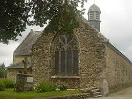
The chapel of Brandérion | ||
| ||
 Brandérion | ||
|
Location within Brittany region  Brandérion | ||
| Coordinates: 47°47′39″N 3°11′36″W / 47.7942°N 3.1933°WCoordinates: 47°47′39″N 3°11′36″W / 47.7942°N 3.1933°W | ||
| Country | France | |
| Region | Brittany | |
| Department | Morbihan | |
| Arrondissement | Lorient | |
| Canton | Hennebont | |
| Intercommunality | Pays de Lorient | |
| Government | ||
| • Mayor (2008–2014) | Hubert de Lageneste | |
| Area1 | 6.03 km2 (2.33 sq mi) | |
| Population (2009)2 | 1,155 | |
| • Density | 190/km2 (500/sq mi) | |
| Time zone | CET (UTC+1) | |
| • Summer (DST) | CEST (UTC+2) | |
| INSEE/Postal code | 56021 / 56700 | |
| Elevation | 8–79 m (26–259 ft) | |
|
1 French Land Register data, which excludes lakes, ponds, glaciers > 1 km² (0.386 sq mi or 247 acres) and river estuaries. 2 Population without double counting: residents of multiple communes (e.g., students and military personnel) only counted once. | ||
.svg.png)
Brandérion (Branderion in Breton) is a commune in the Morbihan department of Brittany in northwestern France.
Population
Inhabitants of Brandérion are called in French Branderionnais.
See also
References
External links
- French Ministry of Culture list for Brandérion (French)
- Map of Brandérion on Michelin (English)
| Wikimedia Commons has media related to Brandérion. |
This article is issued from Wikipedia - version of the 11/7/2016. The text is available under the Creative Commons Attribution/Share Alike but additional terms may apply for the media files.