Houtkerque
| Houtkerque Houtkerke | ||
|---|---|---|
|
Église Saint-Antoine d'Houtkerque | ||
| ||
 Houtkerque | ||
|
Location within Hauts-de-France region  Houtkerque | ||
| Coordinates: 50°52′12″N 2°35′46″E / 50.87°N 2.596°ECoordinates: 50°52′12″N 2°35′46″E / 50.87°N 2.596°E | ||
| Country | France | |
| Region | Hauts-de-France | |
| Department | Nord | |
| Arrondissement | Dunkirk | |
| Canton | Steenvoorde | |
| Intercommunality | Pays des Géants | |
| Government | ||
| • Mayor (2001–2008) | Francis Behaegel | |
| Area1 | 13.13 km2 (5.07 sq mi) | |
| Population (1999)2 | 774 | |
| • Density | 59/km2 (150/sq mi) | |
| Time zone | CET (UTC+1) | |
| • Summer (DST) | CEST (UTC+2) | |
| INSEE/Postal code | 59318 / 59470 | |
| Elevation |
2–22 m (6.6–72.2 ft) (avg. 18 m or 59 ft) | |
|
1 French Land Register data, which excludes lakes, ponds, glaciers > 1 km² (0.386 sq mi or 247 acres) and river estuaries. 2 Population without double counting: residents of multiple communes (e.g., students and military personnel) only counted once. | ||
.jpg)
Houtkerque (from Dutch: Houtkerke) is a communes in the Nord department in northern France. It is located near the Belgian border, 8 km (5.0 mi) north of Steenvoorde, on the Steenvoorde/Hondschoote road. The Yser River crosses the border at Houtkerque.
Houtkerque saw much action during World War I. Seven Commonwealth war graves are situated within Houtkerque's church.
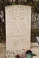 Gravestone
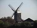 Windmill "Hofland"
.jpg) Mill of Hofland also called mill Accou, Houtkerque, North, France.
Mill of Hofland also called mill Accou, Houtkerque, North, France.
Heraldry
_Nord-France.svg.png) |
The arms of Houtkerque are blazoned : Or, 3 horns sable. |
See also
References
| Wikimedia Commons has media related to Houtkerque. |
This article is issued from Wikipedia - version of the 11/21/2016. The text is available under the Creative Commons Attribution/Share Alike but additional terms may apply for the media files.