Les Brulais
| Les Brulais Ar Brugeier | |
|---|---|
|
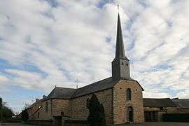
The church of Les Brulais | |
 Les Brulais | |
|
Location within Brittany region  Les Brulais | |
| Coordinates: 47°53′23″N 2°02′30″W / 47.8897°N 2.0417°WCoordinates: 47°53′23″N 2°02′30″W / 47.8897°N 2.0417°W | |
| Country | France |
| Region | Brittany |
| Department | Ille-et-Vilaine |
| Arrondissement | Redon |
| Canton | Maure-de-Bretagne |
| Intercommunality | Pays de Maure-de-Bretagne |
| Government | |
| • Mayor (2014–2020) | Alain Lacorne |
| Area1 | 11.96 km2 (4.62 sq mi) |
| Population (2008)2 | 458 |
| • Density | 38/km2 (99/sq mi) |
| Time zone | CET (UTC+1) |
| • Summer (DST) | CEST (UTC+2) |
| INSEE/Postal code | 35046 / 35330 |
| Elevation | 27–91 m (89–299 ft) |
|
1 French Land Register data, which excludes lakes, ponds, glaciers > 1 km² (0.386 sq mi or 247 acres) and river estuaries. 2 Population without double counting: residents of multiple communes (e.g., students and military personnel) only counted once. | |
Les Brulais (Breton: Ar Brugeier) is a commune in the Ille-et-Vilaine department in Brittany in northwestern France.
Population
Inhabitants of Les Brulais are called Brulaisiens in French.
| Historical population | ||
|---|---|---|
| Year | Pop. | ±% |
| 1962 | 356 | — |
| 1968 | 389 | +9.3% |
| 1975 | 382 | −1.8% |
| 1982 | 362 | −5.2% |
| 1990 | 387 | +6.9% |
| 1999 | 400 | +3.4% |
| 2008 | 458 | +14.5% |
See also
References
External links
| Wikimedia Commons has media related to Les Brulais. |
- Cultural Heritage (French)
- French Ministry of Culture list for Les Brulais (French)
This article is issued from Wikipedia - version of the 7/20/2016. The text is available under the Creative Commons Attribution/Share Alike but additional terms may apply for the media files.