Saint-Uniac
| Saint-Uniac Sant-Tewiniav | |
|---|---|
|
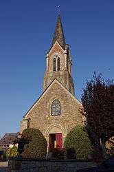
The church of Saint-Uniac | |
 Saint-Uniac | |
|
Location within Brittany region  Saint-Uniac | |
| Coordinates: 48°10′26″N 2°01′39″W / 48.1739°N 2.0275°WCoordinates: 48°10′26″N 2°01′39″W / 48.1739°N 2.0275°W | |
| Country | France |
| Region | Brittany |
| Department | Ille-et-Vilaine |
| Arrondissement | Rennes |
| Canton | Montauban-de-Bretagne |
| Intercommunality | Pays de Montauban-de-Bretagne |
| Government | |
| • Mayor (2014–2020) | Maurice Poulain |
| Area1 | 6.89 km2 (2.66 sq mi) |
| Population (2009)2 | 508 |
| • Density | 74/km2 (190/sq mi) |
| Time zone | CET (UTC+1) |
| • Summer (DST) | CEST (UTC+2) |
| INSEE/Postal code | 35320 / 35360 |
| Elevation | 45–96 m (148–315 ft) |
|
1 French Land Register data, which excludes lakes, ponds, glaciers > 1 km² (0.386 sq mi or 247 acres) and river estuaries. 2 Population without double counting: residents of multiple communes (e.g., students and military personnel) only counted once. | |
Saint-Uniac (Breton: Sant-Tewiniav, Gallo: Saent-Tuniau) is a commune in the Ille-et-Vilaine department in Brittany in northwestern France.
Population
Inhabitants of Saint-Uniac are called Saint-Uniacais in French.
| Historical population | ||
|---|---|---|
| Year | Pop. | ±% |
| 1962 | 212 | — |
| 1968 | 236 | +11.3% |
| 1975 | 233 | −1.3% |
| 1982 | 274 | +17.6% |
| 1990 | 344 | +25.5% |
| 1999 | 350 | +1.7% |
| 2009 | 508 | +45.1% |
See also
References
External links
| Wikimedia Commons has media related to Saint-Uniac. |
- Official website (French)
- French Ministry of Culture list for Saint-Uniac (French)
This article is issued from Wikipedia - version of the 11/6/2015. The text is available under the Creative Commons Attribution/Share Alike but additional terms may apply for the media files.