Clavières
| Clavières | ||
|---|---|---|
|
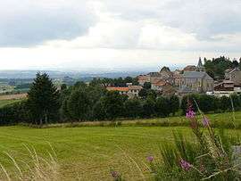
A general view of Clavières | ||
| ||
 Clavières | ||
|
Location within Auvergne-Rhône-Alpes region  Clavières | ||
| Coordinates: 44°59′12″N 3°16′39″E / 44.9867°N 3.2775°ECoordinates: 44°59′12″N 3°16′39″E / 44.9867°N 3.2775°E | ||
| Country | France | |
| Region | Auvergne-Rhône-Alpes | |
| Department | Cantal | |
| Arrondissement | Saint-Flour | |
| Canton | Ruynes-en-Margeride | |
| Intercommunality | Margeride-Truyère | |
| Government | ||
| • Mayor (2008–2014) | Albert Hugon | |
| Area1 | 44.66 km2 (17.24 sq mi) | |
| Population (2008)2 | 240 | |
| • Density | 5.4/km2 (14/sq mi) | |
| Time zone | CET (UTC+1) | |
| • Summer (DST) | CEST (UTC+2) | |
| INSEE/Postal code | 15051 / 15320 | |
| Elevation |
872–1,434 m (2,861–4,705 ft) (avg. 1,060 m or 3,480 ft) | |
|
1 French Land Register data, which excludes lakes, ponds, glaciers > 1 km² (0.386 sq mi or 247 acres) and river estuaries. 2 Population without double counting: residents of multiple communes (e.g., students and military personnel) only counted once. | ||

Clavières is a commune in the Cantal department in south-central France.
Population
| Historical population | ||
|---|---|---|
| Year | Pop. | ±% |
| 1962 | 476 | — |
| 1968 | 477 | +0.2% |
| 1975 | 433 | −9.2% |
| 1982 | 337 | −22.2% |
| 1990 | 308 | −8.6% |
| 1999 | 265 | −14.0% |
| 2008 | 240 | −9.4% |
See also
References
| Wikimedia Commons has media related to Clavières. |
This article is issued from Wikipedia - version of the 2/15/2015. The text is available under the Creative Commons Attribution/Share Alike but additional terms may apply for the media files.