Marcolès
| Marcolès | ||
|---|---|---|
|
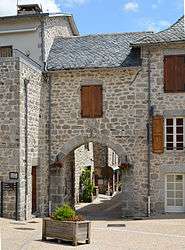
The village gate | ||
| ||
 Marcolès | ||
|
Location within Auvergne-Rhône-Alpes region  Marcolès | ||
| Coordinates: 44°46′59″N 2°21′13″E / 44.7831°N 2.3536°ECoordinates: 44°46′59″N 2°21′13″E / 44.7831°N 2.3536°E | ||
| Country | France | |
| Region | Auvergne-Rhône-Alpes | |
| Department | Cantal | |
| Arrondissement | Aurillac | |
| Canton | Saint-Mamet-la-Salvetat | |
| Intercommunality | Entre Cère et Rance | |
| Government | ||
| • Mayor (2008–2014) | Christian Montin | |
| Area1 | 52.89 km2 (20.42 sq mi) | |
| Population (2008)2 | 611 | |
| • Density | 12/km2 (30/sq mi) | |
| Time zone | CET (UTC+1) | |
| • Summer (DST) | CEST (UTC+2) | |
| INSEE/Postal code | 15117 / 15220 | |
| Elevation |
427–828 m (1,401–2,717 ft) (avg. 710 m or 2,330 ft) | |
|
1 French Land Register data, which excludes lakes, ponds, glaciers > 1 km² (0.386 sq mi or 247 acres) and river estuaries. 2 Population without double counting: residents of multiple communes (e.g., students and military personnel) only counted once. | ||
.svg.png)
Marcolès is a commune in the Cantal department in south-central France.
Population
| Historical population | ||
|---|---|---|
| Year | Pop. | ±% |
| 1962 | 883 | — |
| 1968 | 807 | −8.6% |
| 1975 | 721 | −10.7% |
| 1982 | 654 | −9.3% |
| 1990 | 622 | −4.9% |
| 1999 | 577 | −7.2% |
| 2008 | 611 | +5.9% |
See also
References
| Wikimedia Commons has media related to Marcolès. |
This article is issued from Wikipedia - version of the 2/15/2015. The text is available under the Creative Commons Attribution/Share Alike but additional terms may apply for the media files.