Poyartin
| Poyartin | |
|---|---|
|
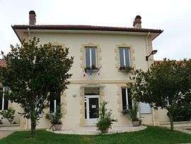
Town hall | |
 Poyartin | |
|
Location within Nouvelle-Aquitaine region  Poyartin | |
| Coordinates: 43°41′10″N 0°51′58″W / 43.6861°N 0.8661°WCoordinates: 43°41′10″N 0°51′58″W / 43.6861°N 0.8661°W | |
| Country | France |
| Region | Nouvelle-Aquitaine |
| Department | Landes |
| Arrondissement | Dax |
| Canton | Montfort-en-Chalosse |
| Intercommunality | Montfort-en-Chalosse |
| Government | |
| • Mayor (2014–2020) | Jean-Yves Dages |
| Area1 | 13.04 km2 (5.03 sq mi) |
| Population (2013)2 | 805 |
| • Density | 62/km2 (160/sq mi) |
| Time zone | CET (UTC+1) |
| • Summer (DST) | CEST (UTC+2) |
| INSEE/Postal code | 40236 / 40380 |
| Elevation |
17–102 m (56–335 ft) (avg. 28 m or 92 ft) |
|
1 French Land Register data, which excludes lakes, ponds, glaciers > 1 km² (0.386 sq mi or 247 acres) and river estuaries. 2 Population without double counting: residents of multiple communes (e.g., students and military personnel) only counted once. | |
Poyartin is a commune in the Landes department in Nouvelle-Aquitaine in southwestern France.
Population
| Historical population | ||
|---|---|---|
| Year | Pop. | ±% |
| 1793 | 950 | — |
| 1806 | 970 | +2.1% |
| 1821 | 1,097 | +13.1% |
| 1831 | 1,097 | +0.0% |
| 1841 | 983 | −10.4% |
| 1851 | 1,042 | +6.0% |
| 1861 | 1,060 | +1.7% |
| 1872 | 1,015 | −4.2% |
| 1881 | 997 | −1.8% |
| 1891 | 939 | −5.8% |
| 1901 | 924 | −1.6% |
| 1911 | 941 | +1.8% |
| 1921 | 796 | −15.4% |
| 1931 | 728 | −8.5% |
| 1946 | 683 | −6.2% |
| 1954 | 636 | −6.9% |
| 1962 | 656 | +3.1% |
| 1968 | 623 | −5.0% |
| 1975 | 629 | +1.0% |
| 1982 | 631 | +0.3% |
| 1990 | 648 | +2.7% |
| 1999 | 631 | −2.6% |
| 2008 | 697 | +10.5% |
| 2013 | 805 | +15.5% |
See also
References
| Wikimedia Commons has media related to Poyartin. |
This article is issued from Wikipedia - version of the 11/10/2016. The text is available under the Creative Commons Attribution/Share Alike but additional terms may apply for the media files.